8.6. Recharge
MINEDW can simulate temporal and spatial variation in recharge. Spatial variation in recharge can be added to a MINEDW model by creating any number of recharge zones and applying those zones to the model domain. Time-series precipitation data can be used to add temporal recharge information to each zone. With MINEDW, the user can also create zones with orographically controlled recharge, which may be useful for mountainous regions.
When “Recharge” is selected from the “BCs” drop-down menu on the Main Menu banner at the top of the screen, the dialog box shown in appears. To create a recharge zone with only temporal variation in recharge, select the “Temporal” tab and then choose “Constant,” “Annual,” or “Varied” for the type of time-series recharge data that will be defined. Next, define the start date and recharge rate in the box below. Note that if the elevation function for recharge is used, then the values defined in the time-series window will not be precipitation rates but rather will be scaling factors. The elevation function for recharge and scaling factors that can be applied are explained on the following pages. A time-series chart appears in the window to the left, displaying the defined data. Note that the units used in this dialog box are specified in the uppermost portion of the window.
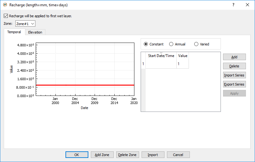
Figure 8.15 The “Recharge” dialog box showing the “Temporal” tab
The “Elevation” tab in the “Recharge” dialog box allows the user to create zones of orographically controlled recharge. Using this method, the net recharge to the groundwater system can be calculated as a percentage (0 to 100%) of the total precipitation that falls in orographically controlled precipitation zones. This method works well for groundwater models that include mountain and valley systems.
Orographically controlled precipitation is calculated using a nonlinear relationship between precipitation and ground-surface elevation. Parameters for the equation below can be estimated by fitting the equation to observed precipitation for a range of elevations. The relationship is defined as follows:
Where:
A = intercept [L/T]
B = constant [L-C]
C = nonlinear scaling factor [-]
z = ground-surface elevation [L]
To activate this option:
Select the “Elevation” tab
Check the box next to the elevation-based precipitation equation
Define the required parameters in the now active dialog boxes (see Figure 8.16)
Below the area where the parameters for the elevation-based recharge equation are defined is a window where elevation factors can be defined. These factors can be used to specify the percentage of total precipitation, calculated by the elevation-based precipitation equation above, that will be applied as recharge to the aquifer for a specific elevation band. For example, consider two different elements with average elevations of 800 and 1,500 m and calculated precipitations of 25 and 80 centimeters per year (cm/yr), respectively. Supposing that two elevation factors were defined as displayed in Figure 8.16, then recharge for the first and second elements would be 8.75 and 60 cm/yr, respectively. The following equation shows how these recharge values are calculated.
Recharge calculated using elevation factors:
Where:
P = precipitation [L/T]
EF = elevation factor [-]
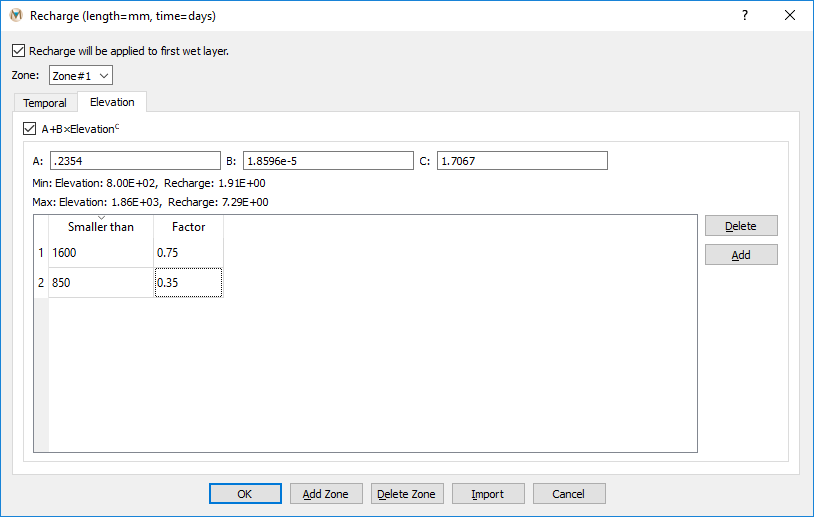
Figure 8.16 Defining parameters for elevation-based recharge
Temporal factors can also be applied to precipitation calculated via the elevation-based precipitation equation. Temporal factors can be applied in addition to ground-surface elevation factors. To define temporal factors, first activate the elevation-based precipitation equation on the “Elevation” tab, define the necessary parameters, and, if desired, define elevation factors. Next, select the “Temporal” tab and create the temporal factors. Temporal factors are defined similarly to temporally varying recharge, as described at the beginning of Time-Series Data. The options for temporal factors are “Constant,” “Annual,” and “Varied.” For illustration purposes, suppose that recharge to an aquifer during winter is reduced because precipitation falls as snow and sublimates rather than melting and infiltrating. In order to account for this phenomenon in the model, the user could define temporal factors to reduce recharge during the winter months. shows an example of how the user might define these annually repeating temporal factors. For January and February, the recharge to the aquifer is 25% of what is calculated by the elevation-based precipitation equation, whereas for March, April, and May, it is 50% of precipitation. For summer months and into fall, recharge is 100% of precipitation, and, finally, for late fall into early winter, recharge is 75% of calculated precipitation. If elevation factors are also defined, then recharge will first be adjusted by the appropriate elevation factor and then by the temporal factor. The following equations show how recharge is calculated using only temporal factors as well as temporal factors with elevation factors.
Recharge calculated using temporal factors:
Where:
TF = temporal factor [-]
Recharge calculated using elevation and temporal factors:
As previously noted, the values defined in the time series section of the “Temporal” tab of the “Recharge” dialog box represent scaling factors if the elevation function is activated. If the elevation function is not used, then these values will be used by the model as precipitation rates.
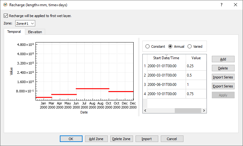
Figure 8.17 Defining temporal factors for elevation-based recharge
If the “Recharge will be applied to first wet layer” box is checked, then recharge is applied directly to the first wet layer; otherwise, it is applied to the top layer.
The required information for recharge zones is described below.
Zone: Number of recharge zones
Rate: Recharge rate (millimeters per day [mm/day] or feet per year [ft/yr]).
To assign the created recharge zones:
Add a “2-D Plane” plot item to the View Pane
Select “Recharge” as the “Color By” option
Click the “Select” tool in the Tool Bar
Select the elements where the first recharge zone is to be assigned
Press Enter when the selection is complete
Select the appropriate recharge zone in the drop-down list
Click “OK” to complete the assignment
Repeat these steps until all zones have been assigned
| Was this helpful? ... | Itasca Software © 2025 | Updated: Sep 23, 2025 |
